IMAGES TAKEN NEAR TO
The Rocks Road, WEST MALLING, ME19 6AU
Introduction
This page details the photographs taken nearby to The Rocks Road, ME19 6AU by members of the Geograph project.
The Geograph project started in 2005 with the aim of publishing, organising and preserving representative images for every square kilometre of Great Britain, Ireland and the Isle of Man.

There are currently over 7.5m images from over14,400 individuals and you can help contribute to the project by visiting https://www.geograph.org.uk
Image Map
Images are licensed for reuse under creativecommons.org/licenses/by-sa/2.0
Notes
- Clicking on the map will re-center to the selected point.
- The higher the marker number, the further away the image location is from the centre of the postcode.
Image Listing (48 Images Found)
Images are licensed for reuse under creativecommons.org/licenses/by-sa/2.0
Image
Details
Distance
2
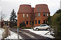
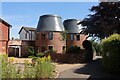
Rocks Oast, The Rocks Road, East Malling, Kent
Image: © Oast House Archive
Taken: 4 Feb 2009
0.02 miles
3
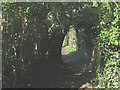
A shady arch
The arch of trees over the public footpath at this bend in its route will provide welcome shade in the summer and shelter in the winter, as well as beckoning the walker on to see what is round the bend.
Image: © Stephen Craven
Taken: 22 Mar 2009
0.06 miles
4
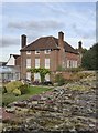
Paris House, The Rocks, East Malling
While in East Malling village I happened to dip into the local Pevsner, and spotted the following entry:
'PARIS HOUSE, The Rocks, 1/4m SE. A highly peculiar early C18 front, two-storeyed, of red brick. Five bays between big symmetrical ragstone chimneybreasts that project from the façade. Panelled parapet below, not in front of, a hipped roof.'
Any building described in Pevsner* as 'peculiar' is likely to be worth a short detour, so I set off along The Rocks Road.
The house is built on a site lower than the road, with a garden to the west enclosed by a high wall. I'd have to agree with John Newman that the building is rather odd - especially those chimneys.
(I have to say, though, that what he reads as a 'parapet' I'd read simply as an attic storey with blocked windows).
* 'The Buildings of England: West Kent and the Weald', John Newman
Image: © Stefan Czapski
Taken: 28 Sep 2017
0.09 miles
5
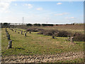
Recently felled trees
Several rows of quite young trees have been felled here, and one row remains on the ground waiting to be collected.
Image: © Stephen Craven
Taken: 22 Mar 2009
0.11 miles
6
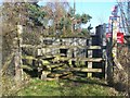
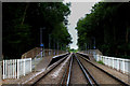
Level Crossing on East Malling footpath
Path leads from The Rocks Road to Church Walk, across railway. Railway heads left to East Malling from Barming.
Image: © David Anstiss
Taken: 27 Jan 2009
0.11 miles
10
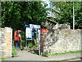
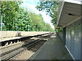
East Malling Station
It is possible to take a photograph of the station from the railway lines, as a public footpath crosses just to the east of the platforms.
The station is on the line between London Victoria and Maidstone East.
Image: © Chris Heaton
Taken: 14 Aug 2016
0.14 miles