IMAGES TAKEN NEAR TO
Church Lane, WEST MALLING, ME19 5SU
Introduction
This page details the photographs taken nearby to Church Lane, ME19 5SU by members of the Geograph project.
The Geograph project started in 2005 with the aim of publishing, organising and preserving representative images for every square kilometre of Great Britain, Ireland and the Isle of Man.

There are currently over 7.5m images from over14,400 individuals and you can help contribute to the project by visiting https://www.geograph.org.uk
Image Map
Images are licensed for reuse under creativecommons.org/licenses/by-sa/2.0
Notes
- Clicking on the map will re-center to the selected point.
- The higher the marker number, the further away the image location is from the centre of the postcode.
Image Listing (130 Images Found)
Images are licensed for reuse under creativecommons.org/licenses/by-sa/2.0
Image
Details
Distance
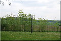
2
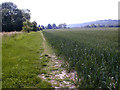
Field view near Trottiscliffe
This view is from the footpath between Trottiscliffe Village and the isolated Trottiscliffe Church.
Image: © Marathon
Taken: 2 Mar 2019
0.06 miles

8
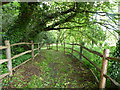
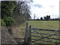
Footpath leading to the church and Trosley Court, Trottiscliffe
Image: © pam fray
Taken: 19 May 2016
0.09 miles
9
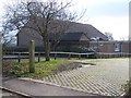
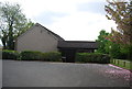
Village Hall
On Church Lane, Trottiscliffe.
Image: © David Anstiss
Taken: 17 Feb 2009
0.10 miles