IMAGES TAKEN NEAR TO
Teston Road, WEST MALLING, ME19 5NF
Introduction
This page details the photographs taken nearby to Teston Road, ME19 5NF by members of the Geograph project.
The Geograph project started in 2005 with the aim of publishing, organising and preserving representative images for every square kilometre of Great Britain, Ireland and the Isle of Man.

There are currently over 7.5m images from over14,400 individuals and you can help contribute to the project by visiting https://www.geograph.org.uk
Image Map
Images are licensed for reuse under creativecommons.org/licenses/by-sa/2.0
Notes
- Clicking on the map will re-center to the selected point.
- The higher the marker number, the further away the image location is from the centre of the postcode.
Image Listing (85 Images Found)
Images are licensed for reuse under creativecommons.org/licenses/by-sa/2.0
Image
Details
Distance
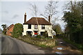
1
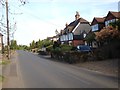
Cottages on Teston Road, Offham
Terrace next to the junction with Church Road. The walls may be made from ragstone which is quarried extensively in the area.
Image: © Paul Harrop
Taken: 8 Sep 2019
0.00 miles
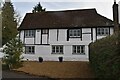
3

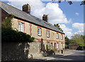
Postern House, Tower Hill, Offham
On the corner of Teston Road, it was formerly The Post Office & General Stores. It is a Grade II listed house of the late 16th century.
Image: © pam fray
Taken: 8 Sep 2019
0.02 miles