IMAGES TAKEN NEAR TO
Teston Road, WEST MALLING, ME19 5NA
Introduction
This page details the photographs taken nearby to Teston Road, ME19 5NA by members of the Geograph project.
The Geograph project started in 2005 with the aim of publishing, organising and preserving representative images for every square kilometre of Great Britain, Ireland and the Isle of Man.

There are currently over 7.5m images from over14,400 individuals and you can help contribute to the project by visiting https://www.geograph.org.uk
Image Map
Images are licensed for reuse under creativecommons.org/licenses/by-sa/2.0
Notes
- Clicking on the map will re-center to the selected point.
- The higher the marker number, the further away the image location is from the centre of the postcode.
Image Listing (25 Images Found)
Images are licensed for reuse under creativecommons.org/licenses/by-sa/2.0
Image
Details
Distance
2
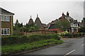
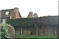
Morphews Oast, Teston Road, Offham, Kent
Image: © Oast House Archive
Taken: 29 May 2008
0.16 miles
3
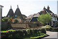
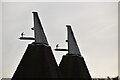
Morphews Oast, Teston Road, Offham, Kent
Image: © Oast House Archive
Taken: 22 Apr 2009
0.16 miles
9
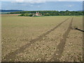
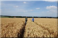
Footpath towards Godwell Farm
This is the view from the edge of Offham as a footpath heads out across the fields. Notices on the path explain that the fields are being managed for wildlife, including skylarks. Just behind is an RSPB hut as well as a small pet cemetery. Godwell Farm and its oasts can be seen in the distance. The path does not go directly to Godwell Farm but turns right at the white post and passes the farm on the far side by a rather circuitous route. The woods in the distance on the left are Whitehorse Wood and Crookhorn Wood on the scarp slope of the North Downs above Ryarsh. On the far right are the woods around Blue Bell Hill on the other side of the Medway Valley.
Image: © Marathon
Taken: 6 Oct 2013
0.19 miles
10
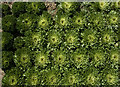
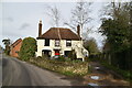
Endives, near Offham
Seen from the public footpath running north east from the village. The surrounding fields were mostly given over to large swathes of endive plants like these, which appeared to have had their top growth harvested.
Image: © Paul Harrop
Taken: 8 Sep 2019
0.20 miles