IMAGES TAKEN NEAR TO
Woodgate Road, WEST MALLING, ME19 5LH
Introduction
This page details the photographs taken nearby to Woodgate Road, ME19 5LH by members of the Geograph project.
The Geograph project started in 2005 with the aim of publishing, organising and preserving representative images for every square kilometre of Great Britain, Ireland and the Isle of Man.

There are currently over 7.5m images from over14,400 individuals and you can help contribute to the project by visiting https://www.geograph.org.uk
Image Map
Images are licensed for reuse under creativecommons.org/licenses/by-sa/2.0
Notes
- Clicking on the map will re-center to the selected point.
- The higher the marker number, the further away the image location is from the centre of the postcode.
Image Listing (22 Images Found)
Images are licensed for reuse under creativecommons.org/licenses/by-sa/2.0
Image
Details
Distance
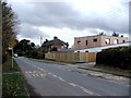
2
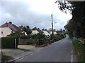
Roughetts Road, Ryarsh
Roughetts Road heading out of the village of Ryarsh in Kent. This image was taken just after a short but heavy rain shower.
Image: © Malc McDonald
Taken: 3 Oct 2021
0.08 miles
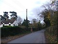
3
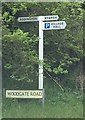
Old Direction Sign - Signpost by Woodgate Road, Ryarsh Parish
No finial - 3 arms; by the UC road, in parish of Ryarsh (Tonbridge And Malling District), Woodgate Road, Roughetts Road crossroads, Ryarsh.
To be surveyed
Milestone Society National ID: KE_TQ6659.
Image: © Milestone Society
Taken: Unknown
0.08 miles
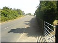
6
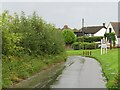
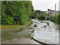
Woodgate Road, Ryarsh
Woodgate Road entering the small village of Ryarsh in Kent. This image was taken just after a short but sharp rain shower.
Image: © Malc McDonald
Taken: 3 Oct 2021
0.10 miles
9
Bridge over M20
This is a view from north of the M20 of the bridge that crosses it.
Image: © Hywel Williams
Taken: 26 Jun 2005
0.15 miles
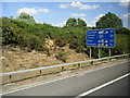
10
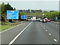
Southbound M20
The second large information sign is interesting in that it uses the "vehicle ferry" symbol - one of the few not just to be a silhouette, as it includes black images of vehicles inside.
Image: © David Dixon
Taken: 15 May 2013
0.15 miles