IMAGES TAKEN NEAR TO
Ryarsh Road, WEST MALLING, ME19 5JW
Introduction
This page details the photographs taken nearby to Ryarsh Road, ME19 5JW by members of the Geograph project.
The Geograph project started in 2005 with the aim of publishing, organising and preserving representative images for every square kilometre of Great Britain, Ireland and the Isle of Man.

There are currently over 7.5m images from over14,400 individuals and you can help contribute to the project by visiting https://www.geograph.org.uk
Image Map
Images are licensed for reuse under creativecommons.org/licenses/by-sa/2.0
Notes
- Clicking on the map will re-center to the selected point.
- The higher the marker number, the further away the image location is from the centre of the postcode.
Image Listing (84 Images Found)
Images are licensed for reuse under creativecommons.org/licenses/by-sa/2.0
Image
Details
Distance
1
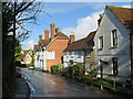
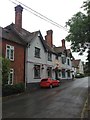
Ryarsh Road, Birling
Ryarsh Road in the village of Birling, in Kent. At the end of the row of cottages is the Nevill Bull pub.
This image was taken on an October afternoon, shortly after a short but heavy rain shower. The sun had come back out, but the road surface was still wet.
Image: © Malc McDonald
Taken: 3 Oct 2021
0.01 miles
2
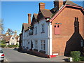
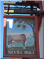
Nevill Bull, Birling
Pub on Ryarsh Road in the centre of Birling.
Image: © Oast House Archive
Taken: 23 Mar 2011
0.03 miles
8
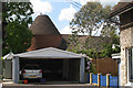
Ashbudd Oast, Snodland Road, Birling, Kent
Image: © Oast House Archive
Taken: 21 May 2009
0.05 miles
9
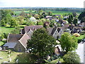
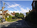
View from the tower of Birling Church
This looks from the top of the tower of All Saints Church across the village of Birling towards the M20. The war memorial can be seen at the bottom of the picture and the church hall is just beyond the churchyard on the left.
Image: © Marathon
Taken: 3 May 2015
0.05 miles
10
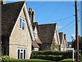
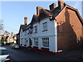
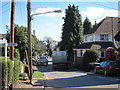
Gabled Roofs
On houses at the corner of Snodland Road and Bull Road.
Image: © Oast House Archive
Taken: 23 Mar 2011
0.05 miles