IMAGES TAKEN NEAR TO
Snodland Road, WEST MALLING, ME19 5JF
Introduction
This page details the photographs taken nearby to Snodland Road, ME19 5JF by members of the Geograph project.
The Geograph project started in 2005 with the aim of publishing, organising and preserving representative images for every square kilometre of Great Britain, Ireland and the Isle of Man.

There are currently over 7.5m images from over14,400 individuals and you can help contribute to the project by visiting https://www.geograph.org.uk
Image Map
Images are licensed for reuse under creativecommons.org/licenses/by-sa/2.0
Notes
- Clicking on the map will re-center to the selected point.
- The higher the marker number, the further away the image location is from the centre of the postcode.
Image Listing (76 Images Found)
Images are licensed for reuse under creativecommons.org/licenses/by-sa/2.0
Image
Details
Distance
2
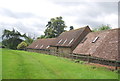
Birling Lodge Oast, Snodland Road, Kent
Image: © Oast House Archive
Taken: 23 Mar 2011
0.04 miles
5
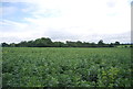
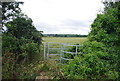
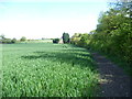
Footpath outside Birling Lodge Farm
The footpath follows the field boundary, beside the high hedgerow.
Image: © Chris Heaton
Taken: 14 Aug 2016
0.07 miles
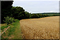
6
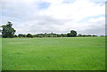
Footpath past Birling Lodge Farm
This footpath from Birling passes Birling Lodge Farm here before continuing on to Birling Place Farm which can be seen in the distance above the right hand side of the gate. Holly Hill Wood on the North Downs lies behind the farm.
Image: © Marathon
Taken: 3 May 2015
0.07 miles
7
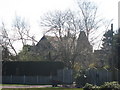
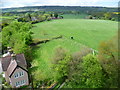
Looking towards All Saints Church, Birling
The church is placed above the village on a bend in the road. The tower is Perpendicular. This view from the north looks across a field of cow parsley.
This was the day of the annual flower festival and it was possible to ascend the tower. The view from the tower looking back here can be seen at http://www.geograph.org.uk/photo/4460721
Image: © Marathon
Taken: 3 May 2015
0.08 miles
8
Footpath to Birling Lodge Farm
This looks from the top of the tower of All Saints Church and along a footpath which passes Birling Lodge Farm. This can be seen in the distance. The North Downs at Trosley Country Park are on the horizon.
Image: © Marathon
Taken: 3 May 2015
0.08 miles
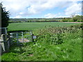
9
Footpath to Birling
Birling Place Farm lies just ahead and then the path continues to Birling where the church tower of All Saints can just be seen.
Image: © Marathon
Taken: 3 May 2015
0.09 miles