IMAGES TAKEN NEAR TO
Birling Road, WEST MALLING, ME19 5JB
Introduction
This page details the photographs taken nearby to Birling Road, ME19 5JB by members of the Geograph project.
The Geograph project started in 2005 with the aim of publishing, organising and preserving representative images for every square kilometre of Great Britain, Ireland and the Isle of Man.

There are currently over 7.5m images from over14,400 individuals and you can help contribute to the project by visiting https://www.geograph.org.uk
Image Map
Images are licensed for reuse under creativecommons.org/licenses/by-sa/2.0
Notes
- Clicking on the map will re-center to the selected point.
- The higher the marker number, the further away the image location is from the centre of the postcode.
Image Listing (26 Images Found)
Images are licensed for reuse under creativecommons.org/licenses/by-sa/2.0
Image
Details
Distance
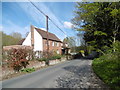
1
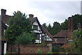
Birling Ashes
Grade II listed, 17th century farmhouse. http://www.britishlistedbuildings.co.uk/en-179272-birling-ashes-birling
Image: © N Chadwick
Taken: 25 Jun 2011
0.01 miles
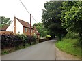
3
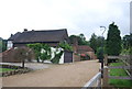
Birling Ashes
A converted 17th century Grade II listed Farmhouse. http://www.britishlistedbuildings.co.uk/en-179272-birling-ashes-birling
Image: © N Chadwick
Taken: 25 Jun 2011
0.03 miles
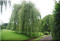
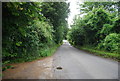
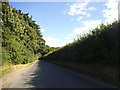
6
Bull Road
This is a continuation of Birling Road after it has crossed over the M20 on the way to Birling.
Image: © Marathon
Taken: 1 May 2016
0.09 miles
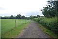
10
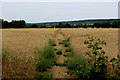
Footpath heading North West from Birling Road
Straight across the field, on a diagonal course to Clacketts Farm.
Image: © Chris Heaton
Taken: 14 Aug 2016
0.13 miles