IMAGES TAKEN NEAR TO
Birling Road, WEST MALLING, ME19 5HZ
Introduction
This page details the photographs taken nearby to Birling Road, ME19 5HZ by members of the Geograph project.
The Geograph project started in 2005 with the aim of publishing, organising and preserving representative images for every square kilometre of Great Britain, Ireland and the Isle of Man.

There are currently over 7.5m images from over14,400 individuals and you can help contribute to the project by visiting https://www.geograph.org.uk
Image Map
Images are licensed for reuse under creativecommons.org/licenses/by-sa/2.0
Notes
- Clicking on the map will re-center to the selected point.
- The higher the marker number, the further away the image location is from the centre of the postcode.
Image Listing (33 Images Found)
Images are licensed for reuse under creativecommons.org/licenses/by-sa/2.0
Image
Details
Distance
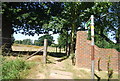
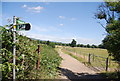
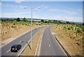
8

Footpath bends to the left
The paths course has been altered by the building of the Leybourne bypass.
Image: © N Chadwick
Taken: 10 Jul 2010
0.15 miles
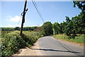
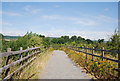
9
Dismounting steps, west of the Leybourne by-pass
Horses must be dismounted to cross the bridge over the Leybourne by-pass.
Image: © N Chadwick
Taken: 10 Jul 2010
0.16 miles
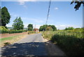
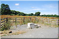
10
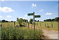
Footpath junction near Leybourne Grange
Image: © N Chadwick
Taken: 10 Jul 2010
0.16 miles