IMAGES TAKEN NEAR TO
Park Road, WEST MALLING, ME19 5HP
Introduction
This page details the photographs taken nearby to Park Road, ME19 5HP by members of the Geograph project.
The Geograph project started in 2005 with the aim of publishing, organising and preserving representative images for every square kilometre of Great Britain, Ireland and the Isle of Man.

There are currently over 7.5m images from over14,400 individuals and you can help contribute to the project by visiting https://www.geograph.org.uk
Image Map
Images are licensed for reuse under creativecommons.org/licenses/by-sa/2.0
Notes
- Clicking on the map will re-center to the selected point.
- The higher the marker number, the further away the image location is from the centre of the postcode.
Image Listing (115 Images Found)
Images are licensed for reuse under creativecommons.org/licenses/by-sa/2.0
Image
Details
Distance
2
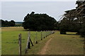
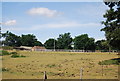
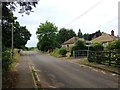
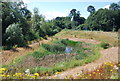
Footpath in Leybourne Park
Path heading north west for the A228.
Image: © Chris Heaton
Taken: 14 Aug 2016
0.06 miles
5
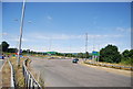
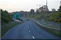
The old A228 (Castle Way) off the new route
Image: © N Chadwick
Taken: 10 Jul 2010
0.09 miles
8
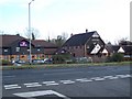
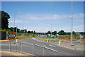
Castle Lake, pub and hotel
On Castle Way, opposite Park Road. Pub/restaurant is part of Brewer's Fayre group. Premier Inn is a motel beside pub.
Image: © David Anstiss
Taken: 27 Jan 2009
0.13 miles