IMAGES TAKEN NEAR TO
Castle Way, WEST MALLING, ME19 5HF
Introduction
This page details the photographs taken nearby to Castle Way, ME19 5HF by members of the Geograph project.
The Geograph project started in 2005 with the aim of publishing, organising and preserving representative images for every square kilometre of Great Britain, Ireland and the Isle of Man.

There are currently over 7.5m images from over14,400 individuals and you can help contribute to the project by visiting https://www.geograph.org.uk
Image Map
Images are licensed for reuse under creativecommons.org/licenses/by-sa/2.0
Notes
- Clicking on the map will re-center to the selected point.
- The higher the marker number, the further away the image location is from the centre of the postcode.
Image Listing (102 Images Found)
Images are licensed for reuse under creativecommons.org/licenses/by-sa/2.0
Image
Details
Distance
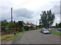
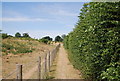
4
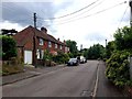
Fenced footpath off Castle Way, Leybourne
Image: © N Chadwick
Taken: 10 Jul 2010
0.13 miles
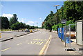
6
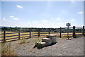
Dismounting steps, east of the Leybourne by-pass
Horses must be dismounted to cross the bridge over the Leybourne by-pass.
Image: © N Chadwick
Taken: 10 Jul 2010
0.15 miles
7
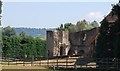
Leybourne Castle
The first date for this castle is 1166. There are traces of a circular earthwork enclosure and part of the powerful twin towered gatehouse which was built in 1275 behind the church. The curtain wall was complete at the start of the 18th century but has since vanished. The remains of the gatehouse and part of the southern tower are now incorporated into a house built in 1930.
Image: © N Chadwick
Taken: 10 Jul 2010
0.16 miles
8
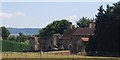
Leybourne Castle and house
There are traces of a circular earthwork enclosure and part of the powerful twin towered gatehouse which was built in 1275 behind the church. The curtain wall was complete at the start of the 18th century but has since vanished. The remains of the gatehouse and part of the southern tower are now incorporated into a house built in 1930.
Image: © N Chadwick
Taken: 10 Jul 2010
0.16 miles
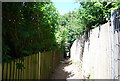
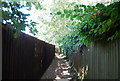
9
Footpath between Leybourne and the by-pass
Image: © N Chadwick
Taken: 10 Jul 2010
0.17 miles
10
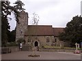
St. Peter & St. Paul church
St. Peter & St. Paul, Leybourne in the diocese of Rochester
Image: © Hywel Williams
Taken: 25 Jun 2005
0.18 miles