IMAGES TAKEN NEAR TO
Brooks Drive, WEST MALLING, ME19 5GS
Introduction
This page details the photographs taken nearby to Brooks Drive, ME19 5GS by members of the Geograph project.
The Geograph project started in 2005 with the aim of publishing, organising and preserving representative images for every square kilometre of Great Britain, Ireland and the Isle of Man.

There are currently over 7.5m images from over14,400 individuals and you can help contribute to the project by visiting https://www.geograph.org.uk
Image Map
Images are licensed for reuse under creativecommons.org/licenses/by-sa/2.0
Notes
- Clicking on the map will re-center to the selected point.
- The higher the marker number, the further away the image location is from the centre of the postcode.
Image Listing (34 Images Found)
Images are licensed for reuse under creativecommons.org/licenses/by-sa/2.0
Image
Details
Distance
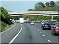
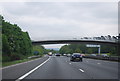
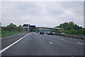
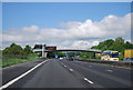
5
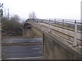
Footbridge over M20 Motorway
On footpath from Church Road to Old School Lane, Ryarsh.
Image: © David Anstiss
Taken: 17 Feb 2009
0.06 miles
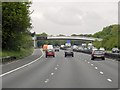
8
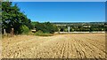
Harvested field next to the M20
Close to Addington and West Malling.
Image: © James Emmans
Taken: 5 Aug 2022
0.12 miles