IMAGES TAKEN NEAR TO
Pinesfield Lane, WEST MALLING, ME19 5EN
Introduction
This page details the photographs taken nearby to Pinesfield Lane, ME19 5EN by members of the Geograph project.
The Geograph project started in 2005 with the aim of publishing, organising and preserving representative images for every square kilometre of Great Britain, Ireland and the Isle of Man.

There are currently over 7.5m images from over14,400 individuals and you can help contribute to the project by visiting https://www.geograph.org.uk
Image Map
Images are licensed for reuse under creativecommons.org/licenses/by-sa/2.0
Notes
- Clicking on the map will re-center to the selected point.
- The higher the marker number, the further away the image location is from the centre of the postcode.
Image Listing (19 Images Found)
Images are licensed for reuse under creativecommons.org/licenses/by-sa/2.0
Image
Details
Distance
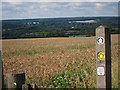
1
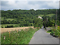
Pinesfield Lane
The North downs seen ahead.
Image: © Oast House Archive
Taken: 24 Jul 2011
0.08 miles
2
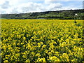
Oilseed rape field near Trottiscliffe
This view looks from the footpath between Pinesfield Lane and Trottiscliffe Church. The North Downs form the background.
Image: © Marathon
Taken: 9 May 2021
0.09 miles
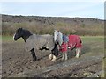
3
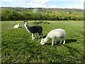
Alpacas in a field
This view is from the car park in Pinesfield Lane along the footpath leading to Coldrum Long Barrow. The woods of Trosley Country Park on the North Downs form the background.
Image: © Marathon
Taken: 9 May 2021
0.11 miles
4
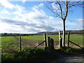
Footpath to Trottiscliffe Church
This view looks from Pinesfield Lane along a footpath leading to Trottiscliffe Church. As it is in a hollow, the top of the church tower is not easily seen from here. To the right of the photograph on the skyline are the North Downs at Trosley Country Park.
Image: © Marathon
Taken: 20 Dec 2014
0.12 miles
5
Horses near Trottiscliffe
These two horses were in a field alongside the path between Trottiscliffe Church and Coldrum Long Barrow. The woods of Trosley Country Park on the North Downs can be seen behind.
Image: © Marathon
Taken: 2 Mar 2019
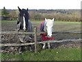
0.13 miles
6
Horses near Trottiscliffe
These two horses were in a field alongside the path between Trottiscliffe Church and Coldrum Long Barrow. The woods of Trosley Country Park on the North Downs can be seen behind.
Image: © Marathon
Taken: 2 Mar 2019
0.13 miles
7
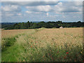
Wheat field
The top of St Peter & St Paul, Trottiscliffe, seen from Pinesfield Lane.
Image: © Oast House Archive
Taken: 24 Jul 2011
0.14 miles
8
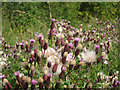
Wild flowers
By footpath to Coldrum Long Barrow.
Image: © Oast House Archive
Taken: 24 Jul 2011
0.14 miles
9
Wheat field
Seen from Pinesfield Lane.
Image: © Oast House Archive
Taken: 24 Jul 2011
0.16 miles
10
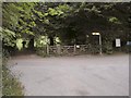
Entrance to Trosley Country Park
The southern foot entrance to Trosley Country Park. The road that runs in front of the gate is part of the Pilgrim's Way, which runs from London to Canterbury
Image: © Hywel Williams
Taken: 25 Jun 2005
0.17 miles