IMAGES TAKEN NEAR TO
Taylors Lane, WEST MALLING, ME19 5DU
Introduction
This page details the photographs taken nearby to Taylors Lane, ME19 5DU by members of the Geograph project.
The Geograph project started in 2005 with the aim of publishing, organising and preserving representative images for every square kilometre of Great Britain, Ireland and the Isle of Man.

There are currently over 7.5m images from over14,400 individuals and you can help contribute to the project by visiting https://www.geograph.org.uk
Image Map
Images are licensed for reuse under creativecommons.org/licenses/by-sa/2.0
Notes
- Clicking on the map will re-center to the selected point.
- The higher the marker number, the further away the image location is from the centre of the postcode.
Image Listing (98 Images Found)
Images are licensed for reuse under creativecommons.org/licenses/by-sa/2.0
Image
Details
Distance
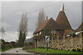
2
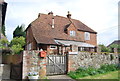
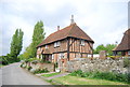
Millers Farmhouse
Grade II listed. http://www.britishlistedbuildings.co.uk/en-427216-miller-s-farmhouse-trottiscliffe-kent
Image: © N Chadwick
Taken: 18 May 2013
0.01 miles
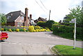
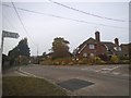
3
Road junction in Trottiscliffe
A crossroads in the Kent village of Trottiscliffe.
Image: © Malc McDonald
Taken: 3 Oct 2021
0.01 miles
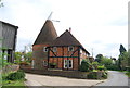
4
Old Roundel Barn, Water Lane, Trottiscliffe, Kent
Image: © Oast House Archive
Taken: 26 Mar 2010
0.01 miles
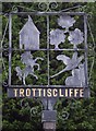
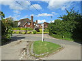
9
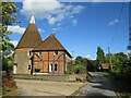
Old Roundel Oast House, Trottiscliffe
An oast house in the village of Trottiscliffe.
Image: © Malc McDonald
Taken: 3 Oct 2021
0.02 miles