IMAGES TAKEN NEAR TO
The Chestnuts, WEST MALLING, ME19 5BH
Introduction
This page details the photographs taken nearby to The Chestnuts, ME19 5BH by members of the Geograph project.
The Geograph project started in 2005 with the aim of publishing, organising and preserving representative images for every square kilometre of Great Britain, Ireland and the Isle of Man.

There are currently over 7.5m images from over14,400 individuals and you can help contribute to the project by visiting https://www.geograph.org.uk
Image Map
Images are licensed for reuse under creativecommons.org/licenses/by-sa/2.0
Notes
- Clicking on the map will re-center to the selected point.
- The higher the marker number, the further away the image location is from the centre of the postcode.
Image Listing (75 Images Found)
Images are licensed for reuse under creativecommons.org/licenses/by-sa/2.0
Image
Details
Distance
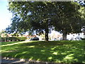
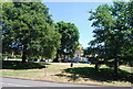
3
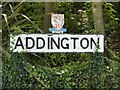
Addington village sign
The badge is for Kent county, Hampshire also made the same designs for their own villages.
Image: © David Howard
Taken: 17 Jul 2016
0.06 miles
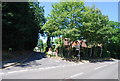
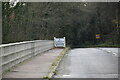
10
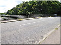
London Countryway in Kent (87)
The M20 is bridged and the route enters Addington.
Image: © Shazz
Taken: 14 Jul 2016
0.09 miles