IMAGES TAKEN NEAR TO
Mill House Lane, WEST MALLING, ME19 5BA
Introduction
This page details the photographs taken nearby to Mill House Lane, ME19 5BA by members of the Geograph project.
The Geograph project started in 2005 with the aim of publishing, organising and preserving representative images for every square kilometre of Great Britain, Ireland and the Isle of Man.

There are currently over 7.5m images from over14,400 individuals and you can help contribute to the project by visiting https://www.geograph.org.uk
Image Map
Images are licensed for reuse under creativecommons.org/licenses/by-sa/2.0
Notes
- Clicking on the map will re-center to the selected point.
- The higher the marker number, the further away the image location is from the centre of the postcode.
Image Listing (71 Images Found)
Images are licensed for reuse under creativecommons.org/licenses/by-sa/2.0
Image
Details
Distance
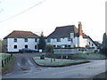
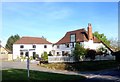
3
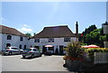
The Angel Pub, Addington
On junction of Trottiscliffe Road (on right) and Millhouse Lane (on left).
Image: © David Anstiss
Taken: 17 Feb 2009
0.06 miles
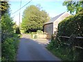
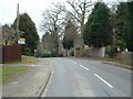
4
Oast Farm, Addington
At end of Millhouse Lane.
Image: © David Anstiss
Taken: 17 Feb 2009
0.06 miles
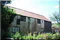
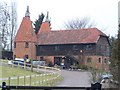
6
Oast house, Oast Farm, Addington
A two kiln oast.
Image: © N Chadwick
Taken: 10 Jul 2010
0.06 miles
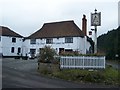
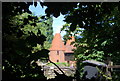
9
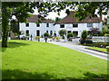
London Countryway in Kent (88)
"The Angel" PH at Addington is attractive. See http://www.geograph.org.uk/photo/1620783 from 2009.
Image: © Shazz
Taken: 14 Jul 2016
0.06 miles