IMAGES TAKEN NEAR TO
London Road, WEST MALLING, ME19 5AL
Introduction
This page details the photographs taken nearby to London Road, ME19 5AL by members of the Geograph project.
The Geograph project started in 2005 with the aim of publishing, organising and preserving representative images for every square kilometre of Great Britain, Ireland and the Isle of Man.

There are currently over 7.5m images from over14,400 individuals and you can help contribute to the project by visiting https://www.geograph.org.uk
Image Map
Images are licensed for reuse under creativecommons.org/licenses/by-sa/2.0
Notes
- Clicking on the map will re-center to the selected point.
- The higher the marker number, the further away the image location is from the centre of the postcode.
Image Listing (14 Images Found)
Images are licensed for reuse under creativecommons.org/licenses/by-sa/2.0
Image
Details
Distance
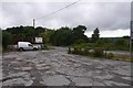
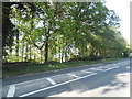
3
Church Road at the junction of the A20
Image: © David Howard
Taken: 12 May 2013
0.07 miles
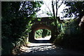
5
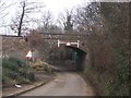
Rail Bridge over Church Road
Church Road leads under bridge from Offham to lead to A20 London Road. The railway heads over bridge left to West Malling from Borough Green.
Image: © David Anstiss
Taken: 17 Feb 2009
0.09 miles
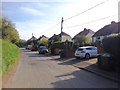
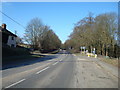
10
London Road, Addington
When you see a P for parking it also has another meaning, and very useful too.
Image: © David Howard
Taken: 12 May 2013
0.20 miles