IMAGES TAKEN NEAR TO
London Road, WEST MALLING, ME19 5AJ
Introduction
This page details the photographs taken nearby to London Road, ME19 5AJ by members of the Geograph project.
The Geograph project started in 2005 with the aim of publishing, organising and preserving representative images for every square kilometre of Great Britain, Ireland and the Isle of Man.

There are currently over 7.5m images from over14,400 individuals and you can help contribute to the project by visiting https://www.geograph.org.uk
Image Map
Images are licensed for reuse under creativecommons.org/licenses/by-sa/2.0
Notes
- Clicking on the map will re-center to the selected point.
- The higher the marker number, the further away the image location is from the centre of the postcode.
Image Listing (10 Images Found)
Images are licensed for reuse under creativecommons.org/licenses/by-sa/2.0
Image
Details
Distance
1
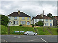
Houses on London Road, A20
Opposite the end of Roughetts Road.
Image: © Robin Webster
Taken: 9 Jun 2012
0.03 miles
2
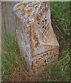
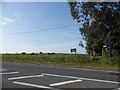
Old Milestone by the A20, London Road, Ryarsh parish
Metal plate attached to stone post by the A20, in parish of RYARSH (TONBRIDGE AND MALLING District), London Road, junction with Roughetts Road, East of bus stop, on the verge between road and path, on North side of road. Kent hipped iron plate, erected by the Wrotham & Maidstone turnpike trust in the 19th century.
Inscription reads:-
: MAIDSTONE / 6 : : TO / LONDON / 28 / --- / Ryarsh : : WROTHAM / 4 :
Grade II listed.
List Entry Number: 1363151 https://historicengland.org.uk/listing/the-list/list-entry/1363151
Milestone Society National ID: KE_LF28.
Image: © C Woodward
Taken: 11 Jun 2008
0.04 miles
6
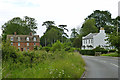
Houses on Roughetts Road
Brook Farm to the right and Brook Cottages to the left.
Image: © Robin Webster
Taken: 9 Jun 2012
0.14 miles
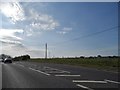
7
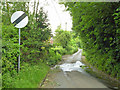
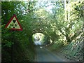
Sandy Lane
Turning off the A20 onto a narrow winding lane, immediately the speed limit is relaxed - so logical!
Image: © Robin Webster
Taken: 9 Jun 2012
0.16 miles
8
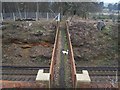
Footbridge over railway
On footpath from Fartherwell Road, near New Town, leads over railway to the A20 London Road. The railway heads left to West Malling from Borough Green.
Image: © David Anstiss
Taken: 17 Feb 2009
0.19 miles
9
Railway Bridge
A railway bridge over a narrow country road.
Image: © Hywel Williams
Taken: 27 Jun 2005
0.19 miles
10
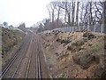
Coppiced trees on railway cutting
These trees along the West Malling to Borough Green railway, have been severely cut back. Many piles of thick logs along the fence line.
Image: © David Anstiss
Taken: 17 Feb 2009
0.22 miles