IMAGES TAKEN NEAR TO
Birling Road, WEST MALLING, ME19 5AA
Introduction
This page details the photographs taken nearby to Birling Road, ME19 5AA by members of the Geograph project.
The Geograph project started in 2005 with the aim of publishing, organising and preserving representative images for every square kilometre of Great Britain, Ireland and the Isle of Man.

There are currently over 7.5m images from over14,400 individuals and you can help contribute to the project by visiting https://www.geograph.org.uk
Image Map
Images are licensed for reuse under creativecommons.org/licenses/by-sa/2.0
Notes
- Clicking on the map will re-center to the selected point.
- The higher the marker number, the further away the image location is from the centre of the postcode.
Image Listing (7 Images Found)
Images are licensed for reuse under creativecommons.org/licenses/by-sa/2.0
Image
Details
Distance
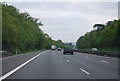
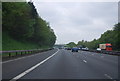
4
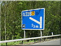
Junction sign eastbound on M20 near Ryarsh
Image: © Colin Pyle
Taken: 13 May 2013
0.15 miles
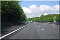
5
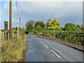
Birling Road, near Ryarsh
Birling Road is a minor road which links the villages of Birling and Ryarsh in Kent. The sign reminds motorists that a 30 miles per hour speed limit applies on this stretch of road.
Image: © Malc McDonald
Taken: 3 Oct 2021
0.20 miles