IMAGES TAKEN NEAR TO
King Hill, WEST MALLING, ME19 4PN
Introduction
This page details the photographs taken nearby to King Hill, ME19 4PN by members of the Geograph project.
The Geograph project started in 2005 with the aim of publishing, organising and preserving representative images for every square kilometre of Great Britain, Ireland and the Isle of Man.

There are currently over 7.5m images from over14,400 individuals and you can help contribute to the project by visiting https://www.geograph.org.uk
Image Map
Images are licensed for reuse under creativecommons.org/licenses/by-sa/2.0
Notes
- Clicking on the map will re-center to the selected point.
- The higher the marker number, the further away the image location is from the centre of the postcode.
Image Listing (5 Images Found)
Images are licensed for reuse under creativecommons.org/licenses/by-sa/2.0
Image
Details
Distance
1
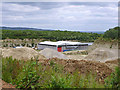
Blaise Farm Quarry composting plant
Part of the facility on the floor of a worked-out part of the quarry. It converts domestic and other waste to compost.
Image: © Robin Webster
Taken: 9 Jun 2012
0.20 miles
2
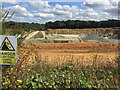
Blaise Farm Quarry, near Offham
Seen from next to the track from Tower Hill to King's Hill.
Blaise Farm Quarry opened in 2001 and was taken over by Gallagher Aggregates in 2005. The 116-hectare site has permission for quarrying 57 million tonnes of ragstone over 62 years. The site includes a composting facility on the floor of the disused quarry.
Image: © Paul Harrop
Taken: 8 Sep 2019
0.22 miles
3
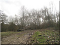
Mereworth Wood
From road to quarry.
Image: © Oast House Archive
Taken: 26 Mar 2010
0.24 miles
4
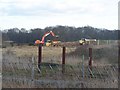
Quarry Works near St Leonard's Wood
As seen from bridlepath No.MR286 to Tower Hill, Offham.
Image: © David Anstiss
Taken: 2 Mar 2009
0.24 miles
5
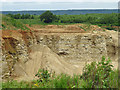
Blaise Farm Quarry
One of the faces in the Hythe Formation.
Image: © Robin Webster
Taken: 9 Jun 2012
0.25 miles