IMAGES TAKEN NEAR TO
Hunt Street, MAIDSTONE, ME18 6AB
Introduction
This page details the photographs taken nearby to Hunt Street, ME18 6AB by members of the Geograph project.
The Geograph project started in 2005 with the aim of publishing, organising and preserving representative images for every square kilometre of Great Britain, Ireland and the Isle of Man.

There are currently over 7.5m images from over14,400 individuals and you can help contribute to the project by visiting https://www.geograph.org.uk
Image Map
Images are licensed for reuse under creativecommons.org/licenses/by-sa/2.0
Notes
- Clicking on the map will re-center to the selected point.
- The higher the marker number, the further away the image location is from the centre of the postcode.
Image Listing (44 Images Found)
Images are licensed for reuse under creativecommons.org/licenses/by-sa/2.0
Image
Details
Distance
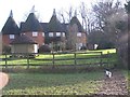
3
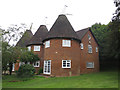
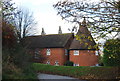
Bow Hill Oast, Hunt Street, Nettlestead
Image: © Oast House Archive
Taken: 6 Sep 2015
0.00 miles
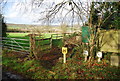
6
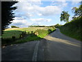
Hunt Street
A quiet lane that runs parallel to the A26 on the other side of the River Medway
Image: © Ron Lee
Taken: 17 Sep 2015
0.01 miles
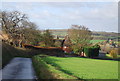
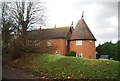
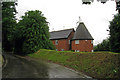
7
Bow Hill Oast House
As seen from footpath from Bow Hill, Wateringbury to Hunt Street. Footpath goes past stile and marked path around garden to road.
Image: © David Anstiss
Taken: 26 Jan 2009
0.01 miles
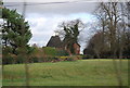
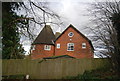
8
Bow Hill Oast, Hunt Street, Nettlestead, Kent
Image: © Oast House Archive
Taken: 29 May 2008
0.01 miles