IMAGES TAKEN NEAR TO
Malling Road, MAIDSTONE, ME18 5QP
Introduction
This page details the photographs taken nearby to Malling Road, ME18 5QP by members of the Geograph project.
The Geograph project started in 2005 with the aim of publishing, organising and preserving representative images for every square kilometre of Great Britain, Ireland and the Isle of Man.

There are currently over 7.5m images from over14,400 individuals and you can help contribute to the project by visiting https://www.geograph.org.uk
Image Map
Images are licensed for reuse under creativecommons.org/licenses/by-sa/2.0
Notes
- Clicking on the map will re-center to the selected point.
- The higher the marker number, the further away the image location is from the centre of the postcode.
Image Listing (39 Images Found)
Images are licensed for reuse under creativecommons.org/licenses/by-sa/2.0
Image
Details
Distance
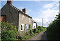
2
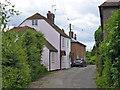
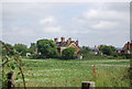
Cottages, Kent Street
A route that became a dead-end when West Malling airfield was built, and remains so since the airfield was redeveloped. There is a pedestrian way through, apparently with no legal status.
Image: © Robin Webster
Taken: 9 Jun 2012
0.10 miles
7
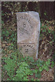
Old Milestone by the A228, Malling Road, West Malling Parish
Metal plate attached to stone post by the A228, in parish of WEST MALLING (TONBRIDGE AND MALLING District), Malling Road, North of crossroads with Kent Street, by entrance to log company (Kate Reed Wood), in the verge, on East side of road. Kent hipped iron plate (Ransomes), erected by the Wrotham & Maidstone turnpike trust in the 19th century.
Inscription reads:- : MEREWORTH / 1 / - : : TO / TONBRIDGE / 8 / - / Aylesford : : WEST MALLING / 2 / - : : (RANSOMES) / IPSWICH :
Milestone Society National ID: KE_WMTB02.
Image: © C Woodward
Taken: 24 Jun 2008
0.14 miles
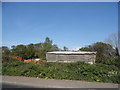
8
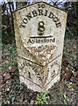
Old Milestone by the A228, Malling Road, West Malling Parish
Metal plate attached to stone post by the A228, in parish of WEST MALLING (TONBRIDGE AND MALLING District), Malling Road, North of crossroads with Kent Street, by entrance to log company (Kate Reed Wood), in the verge, on East side of road. Kent hipped iron plate (Ransomes), erected by the Wrotham & Maidstone turnpike trust in the 19th century.
Inscription reads:- : MEREWORTH / 1 / - : : TO / TONBRIDGE / 8 / - / Aylesford : : WEST MALLING / 2 / - : : (RANSOMES) / IPSWICH :
Milestone Society National ID: KE_WMTB02.
Image: © Simon Westerman
Taken: 1 Jan 2025
0.14 miles