IMAGES TAKEN NEAR TO
Kent Street, MAIDSTONE, ME18 5QN
Introduction
This page details the photographs taken nearby to Kent Street, ME18 5QN by members of the Geograph project.
The Geograph project started in 2005 with the aim of publishing, organising and preserving representative images for every square kilometre of Great Britain, Ireland and the Isle of Man.

There are currently over 7.5m images from over14,400 individuals and you can help contribute to the project by visiting https://www.geograph.org.uk
Image Map
Images are licensed for reuse under creativecommons.org/licenses/by-sa/2.0
Notes
- Clicking on the map will re-center to the selected point.
- The higher the marker number, the further away the image location is from the centre of the postcode.
Image Listing (45 Images Found)
Images are licensed for reuse under creativecommons.org/licenses/by-sa/2.0
Image
Details
Distance
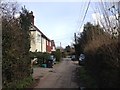
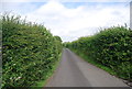
4
Footpath off Beech Road
Beech Road is a narrow road leading from the edge of Kings Hill out into countryside. This short footpath leads from Beech Road to Kent Street.
Image: © Marathon
Taken: 26 Nov 2015
0.07 miles
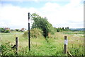
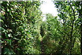
7
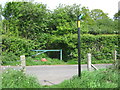
Footpath crosses Beech Road
Footpath from A228 Malling Road, crosses Kent Street and then Beech Road, heading to Mereworth Woods and the Lords Walk.
Image: © David Anstiss
Taken: 6 May 2009
0.08 miles