IMAGES TAKEN NEAR TO
Mill Lane, MAIDSTONE, ME18 5PE
Introduction
This page details the photographs taken nearby to Mill Lane, ME18 5PE by members of the Geograph project.
The Geograph project started in 2005 with the aim of publishing, organising and preserving representative images for every square kilometre of Great Britain, Ireland and the Isle of Man.

There are currently over 7.5m images from over14,400 individuals and you can help contribute to the project by visiting https://www.geograph.org.uk
Image Map
Images are licensed for reuse under creativecommons.org/licenses/by-sa/2.0
Notes
- Clicking on the map will re-center to the selected point.
- The higher the marker number, the further away the image location is from the centre of the postcode.
Image Listing (66 Images Found)
Images are licensed for reuse under creativecommons.org/licenses/by-sa/2.0
Image
Details
Distance
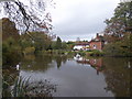
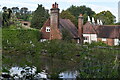
1
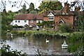
Houses seen across former mill pond beside Mill Lane
Image: © David Martin
Taken: 1 Oct 2022
0.01 miles
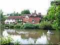
2
The Old Mill Pond, Wateringbury
Many people who visit Wateringbury or pass through do not realise that this tranquil scene exists. The pond is at the centre of a very attractive group of buildings - see https://www.geograph.org.uk/photo/6927218
It can be found down Love Lane or Mill Lane off Tonbridge Road (A26). The stream which forms the Old Mill Pond rises in Hurst Wood and flows through the Fish Pond at Swanton Valley - see https://www.geograph.org.uk/photo/4750605 and then forms the lakes in Mereworth Park, and in due course meets the River Medway near Wateringbury Bridge. It can also be seen at Pizien Well Road, just upstream from here - see https://www.geograph.org.uk/photo/4679132
Image: © Marathon
Taken: 24 Sep 2024
0.02 miles
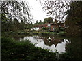
3
The Old Mill Pond, Wateringbury
Many people who visit Wateringbury or pass through do not realise that this tranquil scene exists. The pond is at the centre of a very attractive group of buildings - see https://www.geograph.org.uk/photo/6927218
It can be found down Love Lane or Mill Lane off Tonbridge Road (A26). The stream which forms the Old Mill Pond rises in Hurst Wood and flows through the Fish Pond at Swanton Valley - see https://www.geograph.org.uk/photo/4750605 and then forms the lakes in Mereworth Park, and in due course meets the River Medway near Wateringbury Bridge. It can also be seen at Pizien Well Road, just upstream from here - see https://www.geograph.org.uk/photo/4679132
Image: © Marathon
Taken: 8 Aug 2021
0.02 miles
4

The Old Mill Pond, Wateringbury
Many people who visit Wateringbury or pass through do not realise that this tranquil scene exists. The pond is at the centre of a very attractive group of buildings - see https://www.geograph.org.uk/photo/6927218
It can be found down Love Lane or Mill Lane off Tonbridge Road (A26). The stream which forms the Old Mill Pond rises in Hurst Wood and flows through the Fish Pond at Swanton Valley - see https://www.geograph.org.uk/photo/4750605 and then forms the lakes in Mereworth Park, and in due course meets the River Medway near Wateringbury Bridge. It can also be seen at Pizien Well Road, just upstream from here - see https://www.geograph.org.uk/photo/4679132
Image: © Marathon
Taken: 8 Aug 2021
0.02 miles
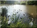
6
The Old Mill Pond, Wateringbury
Many people who visit Wateringbury or pass through do not realise that this tranquil scene exists. The pond is at the centre of a very attractive group of buildings - see https://www.geograph.org.uk/photo/6927218
It can be found down Love Lane or Mill Lane off Tonbridge Road (A26). The stream which forms the Old Mill Pond rises in Hurst Wood and flows through the Fish Pond at Swanton Valley - see https://www.geograph.org.uk/photo/4750605 and then forms the lakes in Mereworth Park, and in due course meets the River Medway near Wateringbury Bridge. It can also be seen at Pizien Well Road, just upstream from here - see https://www.geograph.org.uk/photo/4679132
Image: © Marathon
Taken: 3 Nov 2019
0.03 miles
7
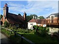
Buildings at the Old Mill near Wateringbury
Many people who visit Wateringbury or pass through do not realise that this tranquil scene exists. An old mill pond is at the centre of a very attractive group of buildings - see https://www.geograph.org.uk/photo/6314686
It can be found down Love Lane or Mill Lane off Tonbridge Road (A26). The stream which forms the Old Mill Pond rises in Hurst Wood and flows through the Fish Pond at Swanton Valley - see https://www.geograph.org.uk/photo/4750605 and then forms the lakes in Mereworth Park, and in due course meets the River Medway near Wateringbury Bridge. It can also be seen at Pizien Well Road, just upstream from here - see https://www.geograph.org.uk/photo/4679132
Image: © Marathon
Taken: 8 Aug 2021
0.03 miles
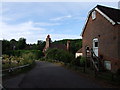
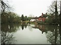
10
Houses below the former mill pond, Mill Lane
Image: © David Martin
Taken: 1 Oct 2022
0.03 miles