IMAGES TAKEN NEAR TO
Tonbridge Road, MAIDSTONE, ME18 5PA
Introduction
This page details the photographs taken nearby to Tonbridge Road, ME18 5PA by members of the Geograph project.
The Geograph project started in 2005 with the aim of publishing, organising and preserving representative images for every square kilometre of Great Britain, Ireland and the Isle of Man.

There are currently over 7.5m images from over14,400 individuals and you can help contribute to the project by visiting https://www.geograph.org.uk
Image Map
Images are licensed for reuse under creativecommons.org/licenses/by-sa/2.0
Notes
- Clicking on the map will re-center to the selected point.
- The higher the marker number, the further away the image location is from the centre of the postcode.
Image Listing (70 Images Found)
Images are licensed for reuse under creativecommons.org/licenses/by-sa/2.0
Image
Details
Distance
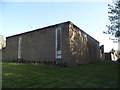
1
Rear of houses on Upper Mill, Wateringbury
Facing Tonbridge Road
Image: © David Howard
Taken: 8 May 2016
0.02 miles
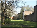
3
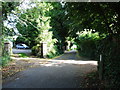
Modern house on Upper Mill, Wateringbury
This is part of a small estate, much backing on to Tonbridge Road to this communal lawn.
Image: © David Howard
Taken: 8 May 2016
0.05 miles
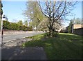
4
Old Milestone by the A26, Tonbridge Road, Wateringbury
Carved stone post by the A26, in parish of WATERINGBURY (TONBRIDGE AND MALLING District), Tonbridge Road, West of Love Lane, in narrow pavement against brick wall, on South side of road. T/M stone, erected by the Tonbridge & Maidstone turnpike trust in the 19th century.
Inscription reads:-
: T / 9 : : M / 5 :
(To Tonbridge and Maidstone)
Carved benchmark and rivet on top.
Kent HER.
HER Number: TQ 65 SE 285 https://www.heritagegateway.org.uk/Gateway/Results_Single.aspx?uid=MKE78160&resourceID=1005
Milestone Society National ID: KE_MDTB05.
Image: © C Woodward
Taken: 8 Aug 2008
0.05 miles
6
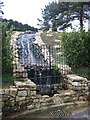
Garden Waterfall on Love Lane
This huge water feature is in The Lodge House. The waterfall feeds into a drain under the road and connects with a stream leading to the river medway.
Image: © David Anstiss
Taken: 5 Mar 2009
0.10 miles
7
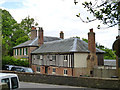
Houses opposite church, Wateringbury
The Beck on the left, Beck Cottage is the timbered part.
Image: © Robin Webster
Taken: 9 Jun 2012
0.11 miles
8
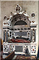
St John the Baptist, Wateringbury - Monument
Image: © John Salmon
Taken: 24 Jul 2014
0.11 miles
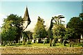
9
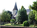
Parish Church of St. John the Baptist, Wateringbury
Image: © Chris Whippet
Taken: 4 Aug 2013
0.11 miles