IMAGES TAKEN NEAR TO
Danns Lane, MAIDSTONE, ME18 5LW
Introduction
This page details the photographs taken nearby to Danns Lane, ME18 5LW by members of the Geograph project.
The Geograph project started in 2005 with the aim of publishing, organising and preserving representative images for every square kilometre of Great Britain, Ireland and the Isle of Man.

There are currently over 7.5m images from over14,400 individuals and you can help contribute to the project by visiting https://www.geograph.org.uk
Image Map
Images are licensed for reuse under creativecommons.org/licenses/by-sa/2.0
Notes
- Clicking on the map will re-center to the selected point.
- The higher the marker number, the further away the image location is from the centre of the postcode.
Image Listing (17 Images Found)
Images are licensed for reuse under creativecommons.org/licenses/by-sa/2.0
Image
Details
Distance


7
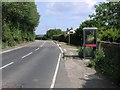
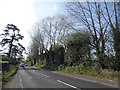
Telephone Box on the A 26 to Maidstone
A public telephone box along the (normally busy) A26 to Maidstone
Image: © Hywel Williams
Taken: 9 Jul 2005
0.21 miles
10
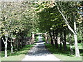
Avenue from Mereworth Castle
This is on the north side of Tonbridge Road. The avenue continues on the south side to Mereworth Castle. In this direction it merely reaches King's Hill.
Image: © Marathon
Taken: 7 Sep 2015
0.23 miles