IMAGES TAKEN NEAR TO
Pizien Well Road, MAIDSTONE, ME18 5HX
Introduction
This page details the photographs taken nearby to Pizien Well Road, ME18 5HX by members of the Geograph project.
The Geograph project started in 2005 with the aim of publishing, organising and preserving representative images for every square kilometre of Great Britain, Ireland and the Isle of Man.

There are currently over 7.5m images from over14,400 individuals and you can help contribute to the project by visiting https://www.geograph.org.uk
Image Map
Images are licensed for reuse under creativecommons.org/licenses/by-sa/2.0
Notes
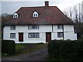
- Clicking on the map will re-center to the selected point.
- The higher the marker number, the further away the image location is from the centre of the postcode.
Image Listing (28 Images Found)
Images are licensed for reuse under creativecommons.org/licenses/by-sa/2.0
Image
Details
Distance
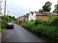
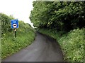
2
Good Intent House
On Pizien Well Road.
Image: © David Anstiss
Taken: 5 Mar 2009
0.01 miles
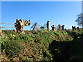
6
A carved hippopotamus
This is one of the carvings along Pizien Well Road seen at https://www.geograph.org.uk/photo/6927181 There is also a rhinoceros - see https://www.geograph.org.uk/photo/6927190
Image: © Marathon
Taken: 8 Aug 2021
0.12 miles
7

A carved hippopotamus
This is one of the carvings along Pizien Well Road seen at https://www.geograph.org.uk/photo/6927181 There is also a rhinoceros - see https://www.geograph.org.uk/photo/6927190
Image: © Marathon
Taken: 8 Aug 2021
0.12 miles
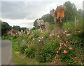
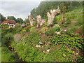
8
Carved tree trunks on Pizien Well Road
This is Pizien Well Road in the hamlet of Pizien Well, to the west of Wateringbury. This small stream meets a larger stream beyond the house in the distance which flows rises in Hurst Wood and flows through the Fish Pond at Swanton Valley - see https://www.geograph.org.uk/photo/4750605 and then forms the lakes in Mereworth Park. Below Pizien Well Road it forms the Old Mill Pond and in due course meets the River Medway near Wateringbury Bridge.
A local man has created this wonderful bank of flowers and after the line of trees were felled has carved a couple of them into animal heads - see https://www.geograph.org.uk/photo/6927190 and https://www.geograph.org.uk/photo/6927197 The nearest one is the rhinoceros.
Image: © Marathon
Taken: 30 Mar 2024
0.12 miles
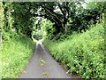
9
Park Road along East Woods
A small country lane towards Nettlestead.
Image: © J.Hannan-Briggs
Taken: 3 Feb 2014
0.12 miles
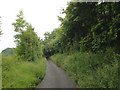
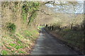
10
Pizien Well Road
This is Pizien Well Road in the hamlet of Pizien Well, to the west of Wateringbury. This small stream meets a larger stream beyond the house in the distance which flows rises in Hurst Wood and flows through the Fish Pond at Swanton Valley - see https://www.geograph.org.uk/photo/4750605 and then forms the lakes in Mereworth Park. Below Pizien Well Road it forms the Old Mill Pond and in due course meets the River Medway near Wateringbury Bridge.
A local man has created this wonderful bank of flowers and after the line of trees were felled has carved a couple of them into animal heads - see https://www.geograph.org.uk/photo/6927190 and https://www.geograph.org.uk/photo/6927197
Image: © Marathon
Taken: 8 Aug 2021
0.14 miles