IMAGES TAKEN NEAR TO
Teston Road, MAIDSTONE, ME18 5BG
Introduction
This page details the photographs taken nearby to Teston Road, ME18 5BG by members of the Geograph project.
The Geograph project started in 2005 with the aim of publishing, organising and preserving representative images for every square kilometre of Great Britain, Ireland and the Isle of Man.

There are currently over 7.5m images from over14,400 individuals and you can help contribute to the project by visiting https://www.geograph.org.uk
Image Map
Images are licensed for reuse under creativecommons.org/licenses/by-sa/2.0
Notes
- Clicking on the map will re-center to the selected point.
- The higher the marker number, the further away the image location is from the centre of the postcode.
Image Listing (19 Images Found)
Images are licensed for reuse under creativecommons.org/licenses/by-sa/2.0
Image
Details
Distance
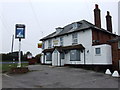
1
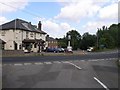
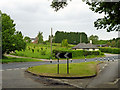
The North Pole
At the meeting point of 5 roads, the North Pole is a significant landmark for this square.
Image: © Hywel Williams
Taken: 9 Jul 2005
0.08 miles
2
Tollgate Cottage
Tollgate Cottage is on the busy Wateringbury Road on the corner with Teston Road. In view of its proximity to the main road and its name, it presumably dates from the days of the turnpikes.
Image: © Marathon
Taken: 11 Jul 2013
0.09 miles
4
The North Pole
Located at a meeting place of 5 roads - including Wateringbury Road, Teston Street and a lane now reduced to a non vehicular track called Livesey Street.
Image: © Chris Heaton
Taken: 13 Aug 2016
0.09 miles
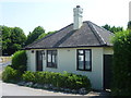
5
At the junction
Malling Road meets Red Hill, with Teston Road opposite to the right of the bungalow.
Image: © Robin Webster
Taken: 4 Jun 2012
0.10 miles
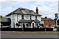
6
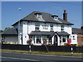
North Pole pub on Wateringbury Road
This prominently placed pub is on the corner of Wateringbury Road and Livesey Street. This is the view from Teston Street opposite.
Image: © Marathon
Taken: 11 Jul 2013
0.10 miles
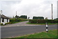
8
Barming Road
Lane heading east off Wateringbury Road
Image: © Chris Heaton
Taken: 13 Aug 2016
0.12 miles
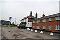
9
North Pole, near Wateringbury
Yet another pub that has recently closed down. Here is a picture of it earlier in 2009.
http://www.geograph.org.uk/photo/1266501
Image: © Chris Whippet
Taken: 28 Oct 2009
0.12 miles
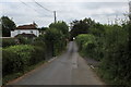
10
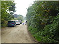
Teston Road viewed from the footpath from Kings Hill
This road originally went to the land now occupied by the Kings Hill estate. It was closed during World War 2 when the land was an aerodrome. It is now a popular place to start dog walks through the woods that surround the estate.
Image: © Ron Lee
Taken: 15 Oct 2016
0.14 miles