IMAGES TAKEN NEAR TO
Bramble Close, ME17 4UA
Introduction
This page details the photographs taken nearby to Bramble Close, ME17 4UA by members of the Geograph project.
The Geograph project started in 2005 with the aim of publishing, organising and preserving representative images for every square kilometre of Great Britain, Ireland and the Isle of Man.

There are currently over 7.5m images from over14,400 individuals and you can help contribute to the project by visiting https://www.geograph.org.uk
Image Map
Images are licensed for reuse under creativecommons.org/licenses/by-sa/2.0
Notes
- Clicking on the map will re-center to the selected point.
- The higher the marker number, the further away the image location is from the centre of the postcode.
Image Listing (9 Images Found)
Images are licensed for reuse under creativecommons.org/licenses/by-sa/2.0
Image
Details
Distance
5

Bird in Hand (Coxheath)
The beacon on the left is a replica of an Armada Beacon
Image: © Deri James
Taken: 4 Sep 2005
0.24 miles
8
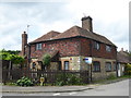
Firtree Cottage, Coxheath
Maps of the 19th century show Firtree Cottage in Forstal Lane as being quite isolated with the nearest village being at Loose. The growth of Coxheath in the 20th century means that the house is now very much on the edge of the village and surrounded by modern houses.
Image: © Marathon
Taken: 5 Jun 2017
0.25 miles