IMAGES TAKEN NEAR TO
Broad Drive, MAIDSTONE, ME17 4SW
Introduction
This page details the photographs taken nearby to Broad Drive, ME17 4SW by members of the Geograph project.
The Geograph project started in 2005 with the aim of publishing, organising and preserving representative images for every square kilometre of Great Britain, Ireland and the Isle of Man.

There are currently over 7.5m images from over14,400 individuals and you can help contribute to the project by visiting https://www.geograph.org.uk
Image Map
Images are licensed for reuse under creativecommons.org/licenses/by-sa/2.0
Notes
- Clicking on the map will re-center to the selected point.
- The higher the marker number, the further away the image location is from the centre of the postcode.
Image Listing (60 Images Found)
Images are licensed for reuse under creativecommons.org/licenses/by-sa/2.0
Image
Details
Distance
1
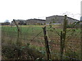
Chicken Sheds, Lyewood Farm, Boughton Monchelsea
Image: © Danny P Robinson
Taken: 26 Dec 2012
0.03 miles
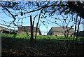
4

Looking northwest towards Lyewood Farm
A large free range and barn chicken farm is hidden just behind the trees.
Image: © David Rayner
Taken: 24 Dec 2005
0.06 miles
10
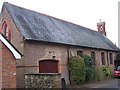
St. Augustines
Former St Augustine's Chapel now converted into a house on The Quarries Road.
Image: © David Anstiss
Taken: 20 Jan 2009
0.09 miles