IMAGES TAKEN NEAR TO
Old Tree Lane, MAIDSTONE, ME17 4NG
Introduction
This page details the photographs taken nearby to Old Tree Lane, ME17 4NG by members of the Geograph project.
The Geograph project started in 2005 with the aim of publishing, organising and preserving representative images for every square kilometre of Great Britain, Ireland and the Isle of Man.

There are currently over 7.5m images from over14,400 individuals and you can help contribute to the project by visiting https://www.geograph.org.uk
Image Map (Loading...)


Getting Data...Please wait
Leaflet Map data © OpenStreetMap
Images are licensed for reuse under creativecommons.org/licenses/by-sa/2.0
Notes
- Clicking on the map will re-center to the selected point.
- The higher the marker number, the further away the image location is from the centre of the postcode.
Image Listing (29 Images Found)
Images are licensed for reuse under creativecommons.org/licenses/by-sa/2.0
Image
Details
Distance

2

Stream Shaw
Very close to the source of this small stream, which eventually flows into the River Medway.
Image: © N Chadwick
Taken: 27 Nov 2011
0.08 miles


6

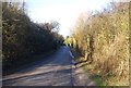
Brishing Lane, near Boughton Monchelsea
Image: © Chris Whippet
Taken: 26 Feb 2016
0.11 miles


9
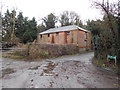
Derelict Building at the Bottom of Old Tree Lane
Image: © Danny P Robinson
Taken: 26 Dec 2012
0.14 miles
10
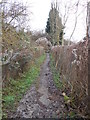
Footpath between Old Tree Lane and Brishing Lane
Image: © Danny P Robinson
Taken: 26 Dec 2012
0.14 miles