IMAGES TAKEN NEAR TO
Boughton Lane, MAIDSTONE, ME17 4NA
Introduction
This page details the photographs taken nearby to Boughton Lane, ME17 4NA by members of the Geograph project.
The Geograph project started in 2005 with the aim of publishing, organising and preserving representative images for every square kilometre of Great Britain, Ireland and the Isle of Man.

There are currently over 7.5m images from over14,400 individuals and you can help contribute to the project by visiting https://www.geograph.org.uk
Image Map
Images are licensed for reuse under creativecommons.org/licenses/by-sa/2.0
Notes
- Clicking on the map will re-center to the selected point.
- The higher the marker number, the further away the image location is from the centre of the postcode.
Image Listing (28 Images Found)
Images are licensed for reuse under creativecommons.org/licenses/by-sa/2.0
Image
Details
Distance
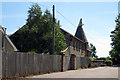
1

Footpath heading south to Boughton Mount
Image: © N Chadwick
Taken: 27 Nov 2011
0.07 miles
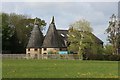
2
Boughton Mount Oast, Boughton Lane, Boughton Monchelsea, Kent
Image: © Oast House Archive
Taken: 24 Jun 2008
0.07 miles

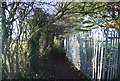
5

Boughton Mount Centre, Boughton Lane
Now derelict, this used to be a social services building.
Image: © Danny P Robinson
Taken: 26 May 2013
0.11 miles
7

House in Boughton Mount Centre
This is now derelict. Boughton Mount Centre used to be a social services facility.
Image: © Danny P Robinson
Taken: 26 May 2013
0.12 miles
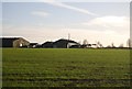
8
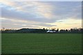
Looking southwest towards Boughton Mount Farm
Farmland on the southern edge of Maidstone
Image: © David Rayner
Taken: 24 Dec 2005
0.14 miles
10
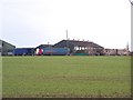
Boughton Mount Farm
Part of Fruit Direct - Controlled atmosphere storage. As seen from footpath from Boughton Lane to Pested Bar Road.
Image: © David Anstiss
Taken: 20 Jan 2009
0.15 miles