IMAGES TAKEN NEAR TO
Haste Hill Road, MAIDSTONE, ME17 4LP
Introduction
This page details the photographs taken nearby to Haste Hill Road, ME17 4LP by members of the Geograph project.
The Geograph project started in 2005 with the aim of publishing, organising and preserving representative images for every square kilometre of Great Britain, Ireland and the Isle of Man.

There are currently over 7.5m images from over14,400 individuals and you can help contribute to the project by visiting https://www.geograph.org.uk
Image Map
Images are licensed for reuse under creativecommons.org/licenses/by-sa/2.0
Notes
- Clicking on the map will re-center to the selected point.
- The higher the marker number, the further away the image location is from the centre of the postcode.
Image Listing (61 Images Found)
Images are licensed for reuse under creativecommons.org/licenses/by-sa/2.0
Image
Details
Distance


4
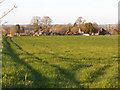
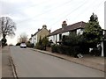
Field, and houses on Haste Hill Road, Boughton Monchelsea (2)
Image: © Danny P Robinson
Taken: 18 Apr 2015
0.04 miles
5
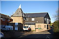
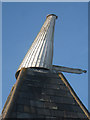
Cart Lodge Oast, Haste Hill Road, Boughton Monchelsea, Kent
Image: © Oast House Archive
Taken: 23 Sep 2007
0.04 miles
6

Cart Lodge Oast, Haste Hill Road, Boughton Monchelsea, Kent
Image: © Oast House Archive
Taken: 9 Oct 2008
0.05 miles
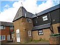
8
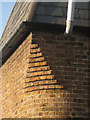
Brick detail on Cart Lodge Oast
Corbelled brick detail at the top of a curve corner of the square kiln, bringing the roof plan back to square.
Image: © Oast House Archive
Taken: 19 Nov 2010
0.06 miles