IMAGES TAKEN NEAR TO
Heath Road, MAIDSTONE, ME17 4JN
Introduction
This page details the photographs taken nearby to Heath Road, ME17 4JN by members of the Geograph project.
The Geograph project started in 2005 with the aim of publishing, organising and preserving representative images for every square kilometre of Great Britain, Ireland and the Isle of Man.

There are currently over 7.5m images from over14,400 individuals and you can help contribute to the project by visiting https://www.geograph.org.uk
Image Map
Images are licensed for reuse under creativecommons.org/licenses/by-sa/2.0
Notes
- Clicking on the map will re-center to the selected point.
- The higher the marker number, the further away the image location is from the centre of the postcode.
Image Listing (12 Images Found)
Images are licensed for reuse under creativecommons.org/licenses/by-sa/2.0
Image
Details
Distance
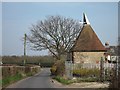
2

Oast House at Marlpit Farm, Wierton Road, Boughton Monchelsea, Kent
Image: © Oast House Archive
Taken: 19 Nov 2010
0.07 miles
3
Oast House at Marlpit Farm, Wierton Road, Boughton Monchelsea
Image: © Oast House Archive
Taken: 22 Mar 2012
0.07 miles
4
Oast House at Marlpit Farm, Wierton Road, Boughton Monchelsea, Kent
Image: © Oast House Archive
Taken: 23 Sep 2007
0.09 miles
5
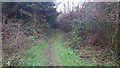
Footpath near Iden Farm
On access road to Farm house from Heath Road. Footpath No.KM115 leads to Brishing Road, Park Wood.
Image: © David Anstiss
Taken: 20 Jan 2009
0.15 miles
6
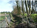
Footpath alongside an earthwork
This footpath goes between Wierton Lane and Back Lane. The Ordnance Survey Map marks an earthwork where the bank can be seen to the right of the footpath.
Image: © Marathon
Taken: 12 Mar 2015
0.15 miles
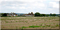
7
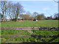
View from Wierton Lane
A footpath passes just beyond the left hand side of the field, and the Ordnance Survey Map also marks an earthwork where the bank can be seen this side of the footpath. See also http://www.geograph.org.uk/photo/4383250
Image: © Marathon
Taken: 12 Mar 2015
0.16 miles
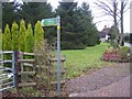
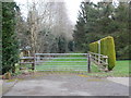
9
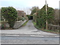
Public Footpath leading to Iden Farm
This photo is taken from Heath Road. The footpath is not signposted so would not be obvious from the roadway.
Image: © Danny P Robinson
Taken: 1 Feb 2015
0.18 miles
10
Public Footpath leading to Iden Farm
This is where the driveway in Image] comes to an end.
Image: © Danny P Robinson
Taken: 1 Feb 2015
0.18 miles