IMAGES TAKEN NEAR TO
Castle Way, MAIDSTONE, ME17 4GQ
Introduction
This page details the photographs taken nearby to Castle Way, ME17 4GQ by members of the Geograph project.
The Geograph project started in 2005 with the aim of publishing, organising and preserving representative images for every square kilometre of Great Britain, Ireland and the Isle of Man.

There are currently over 7.5m images from over14,400 individuals and you can help contribute to the project by visiting https://www.geograph.org.uk
Image Map
Images are licensed for reuse under creativecommons.org/licenses/by-sa/2.0
Notes
- Clicking on the map will re-center to the selected point.
- The higher the marker number, the further away the image location is from the centre of the postcode.
Image Listing (35 Images Found)
Images are licensed for reuse under creativecommons.org/licenses/by-sa/2.0
Image
Details
Distance
1
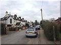
Field off Heath Road, Boughton Monchelsea
The houses are on Lewis Court Drive. The field is on the corner of Heath Road and Church Street.
Image: © Danny P Robinson
Taken: 18 Apr 2015
0.02 miles
2
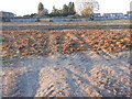
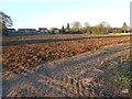
Field off Heath Road, Boughton Monchelsea
The houses in the background are on Lewis Court Drive. The field is on the corner of Church Street and Heath Road.
Image: © Danny P Robinson
Taken: 18 Apr 2015
0.03 miles
3
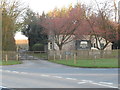
Gatehouse, Boughton Monchelsea Place
On the corner of Heath Road and Church Hill.
Image: © Danny P Robinson
Taken: 18 Apr 2015
0.06 miles
4
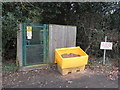
Electricity Substation and Salt Bin, Church Hill, Boughton Monchelsea
Image: © Danny P Robinson
Taken: 3 Mar 2013
0.07 miles
6
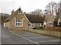
Boughton Monchelsea Primary School
Here is a link to their website http://www.boughton-monchelsea.kent.sch.uk/default.aspx
The address is on Church Hill, not (as the 1:25000 OS states) Church Lane.
Image: © Danny P Robinson
Taken: 26 Dec 2012
0.09 miles
7
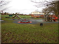
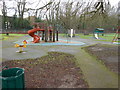
Playground, Village Hall, Playing Field: Boughton Monchelsea
Image: © Danny P Robinson
Taken: 26 Dec 2012
0.10 miles
8
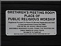
Sign outside Brethren's Meeting Room, Church Hill
This is the only sign that gives any indication what this building is or what goes on here Image] . It says "BRETHREN'S MEETING ROOM PLACE OF PUBLIC RELIGIOUS WORSHIP Registered Pursuant To Places Of Worship Registration Act 1855 & Local government Finance Act 1988 FOR DETAIL OF GOSPEL PREACHINGS AND BIBLE READINGS PLEASE PHONE THE TRUSTEES ON 01622 749618 OR 01622 715270 OR WRITE TO THEM AT MEETING ROOM, HEATH ROAD, LINTON, MAIDSTONE, ME17 4HT"
They clearly don't encourage casual callers, or the more usual church activities like mother & toddler groups, bring and buy sales or feeding programmes for people in need.
I have transcribed the case exactly as written on the sign and I note that "government" is the only word starting in a lower case letter.
Image: © Danny P Robinson
Taken: 3 Mar 2013
0.10 miles
9
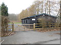
Exclusive Brethren Meeting Room, Church Hill, Boughton Monchelsea
This appears to be a satellite meeting room of the much larger one on Heath Road nearby Image] . I have never yet seen it in use.
Image: © Danny P Robinson
Taken: 3 Mar 2013
0.11 miles