IMAGES TAKEN NEAR TO
Hermitage Lane, MAIDSTONE, ME17 4DA
Introduction
This page details the photographs taken nearby to Hermitage Lane, ME17 4DA by members of the Geograph project.
The Geograph project started in 2005 with the aim of publishing, organising and preserving representative images for every square kilometre of Great Britain, Ireland and the Isle of Man.

There are currently over 7.5m images from over14,400 individuals and you can help contribute to the project by visiting https://www.geograph.org.uk
Image Map
Images are licensed for reuse under creativecommons.org/licenses/by-sa/2.0
Notes
- Clicking on the map will re-center to the selected point.
- The higher the marker number, the further away the image location is from the centre of the postcode.
Image Listing (11 Images Found)
Images are licensed for reuse under creativecommons.org/licenses/by-sa/2.0
Image
Details
Distance
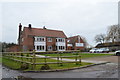
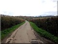
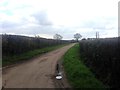
2
Hermitage Lane, near Boughton Monchelsea
Image: © Chris Whippet
Taken: 8 Apr 2016
0.06 miles
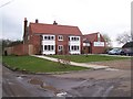
3
The Mulberry Tree, near Boughton Monchelsea
Image: © Chris Whippet
Taken: 8 Apr 2016
0.07 miles
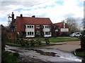
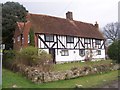
4
The Mulberry Tree Restaurant
On Hermitage Lane. Was the Red House Public House.
Image: © David Anstiss
Taken: 13 Mar 2009
0.07 miles
5
East Hall Hill, near Boughton Monchelsea
Image: © Chris Whippet
Taken: 8 Apr 2016
0.08 miles
6
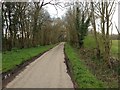
Hermitage Lane, near Boughton Monchelsea
Image: © Chris Whippet
Taken: 8 Apr 2016
0.09 miles
7
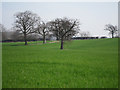
Field by East Hall Hill
Individual trees in a crop field north of Whiteways Farm.
Image: © Oast House Archive
Taken: 22 Mar 2012
0.13 miles
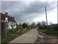
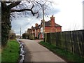
10
Lucks Cottage
On Hermitage Lane. The footpath on left leads up to the Greensand Way (long distance path).
Image: © David Anstiss
Taken: 13 Mar 2009
0.19 miles