IMAGES TAKEN NEAR TO
Peens Lane, MAIDSTONE, ME17 4BY
Introduction
This page details the photographs taken nearby to Peens Lane, ME17 4BY by members of the Geograph project.
The Geograph project started in 2005 with the aim of publishing, organising and preserving representative images for every square kilometre of Great Britain, Ireland and the Isle of Man.

There are currently over 7.5m images from over14,400 individuals and you can help contribute to the project by visiting https://www.geograph.org.uk
Image Map
Images are licensed for reuse under creativecommons.org/licenses/by-sa/2.0
Notes
- Clicking on the map will re-center to the selected point.
- The higher the marker number, the further away the image location is from the centre of the postcode.
Image Listing (8 Images Found)
Images are licensed for reuse under creativecommons.org/licenses/by-sa/2.0
Image
Details
Distance
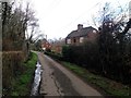
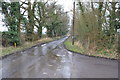
2
Bishop's Farm House
On bend in Peens Lane.
Image: © David Anstiss
Taken: 13 Mar 2009
0.04 miles
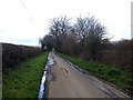
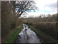
5
Long Lane
At the time the picture was taken there were large amounts of water running down the lane. Also plenty of Mud!
Image: © Julian P Guffogg
Taken: 16 Feb 2013
0.16 miles
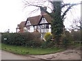
6
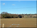
View north from Lower Farm Road
The hedgerow on the left follows Long Lane.
Image: © Robin Webster
Taken: 16 Feb 2014
0.18 miles
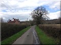
7
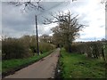
Hermitage Lane, near Boughton Monchelsea
Image: © Chris Whippet
Taken: 8 Apr 2016
0.19 miles