IMAGES TAKEN NEAR TO
ME17 3XN
Introduction
This page details the photographs taken nearby to ME17 3XN by members of the Geograph project.
The Geograph project started in 2005 with the aim of publishing, organising and preserving representative images for every square kilometre of Great Britain, Ireland and the Isle of Man.

There are currently over 7.5m images from over14,400 individuals and you can help contribute to the project by visiting https://www.geograph.org.uk
Image Map
Images are licensed for reuse under creativecommons.org/licenses/by-sa/2.0
Notes
- Clicking on the map will re-center to the selected point.
- The higher the marker number, the further away the image location is from the centre of the postcode.
Image Listing (10 Images Found)
Images are licensed for reuse under creativecommons.org/licenses/by-sa/2.0
Image
Details
Distance
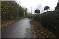
1
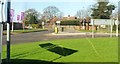
New junction near Bicknor Farm
Roundabout (not indicated on OS map) is now part of the turning off the A274 into the Langley Park Estate - a Taylor Wimpey housing development.
Image: © Clint Mann
Taken: 16 Feb 2016
0.21 miles
3
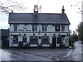
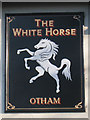
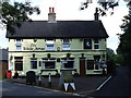
The White Horse Pub, Otham
On junction of White Horse Lane (on left) and Honey Lane (on right).
Image: © David Anstiss
Taken: 20 Jan 2009
0.22 miles
5
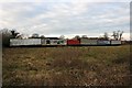
Heavy Goods Vehicles Graveyard in Kent
These old lorries are lying idle in a field on the outskirts of Maidstone in Kent.
Image: © David Rayner
Taken: 24 Dec 2005
0.23 miles
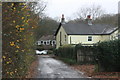
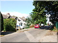
8
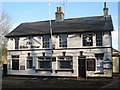
The White Horse, Otham
Closed pub at corner of White Horse Lane (left) and Honey Lane.
Also see Image
Image: © Oast House Archive
Taken: 26 Nov 2010
0.23 miles