IMAGES TAKEN NEAR TO
Allfrey Road, MAIDSTONE, ME17 3SZ
Introduction
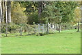
This page details the photographs taken nearby to Allfrey Road, ME17 3SZ by members of the Geograph project.
The Geograph project started in 2005 with the aim of publishing, organising and preserving representative images for every square kilometre of Great Britain, Ireland and the Isle of Man.

There are currently over 7.5m images from over14,400 individuals and you can help contribute to the project by visiting https://www.geograph.org.uk
Image Map
Images are licensed for reuse under creativecommons.org/licenses/by-sa/2.0
Notes
- Clicking on the map will re-center to the selected point.
- The higher the marker number, the further away the image location is from the centre of the postcode.
Image Listing (14 Images Found)
Images are licensed for reuse under creativecommons.org/licenses/by-sa/2.0
Image
Details
Distance
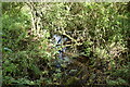
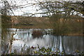
1

Weir Near Mount Pleasant Farm.
The weir in the background holds back the waters of a lake on the footpath from
Image and Mount Pleasant Farm.
Image: © Glyn Baker
Taken: 5 Aug 2006
0.15 miles
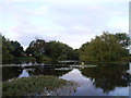
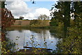
9
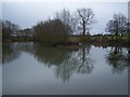
Langley Loch from the Weir
The weir slows path of river down to make this pond. Many ducks and other waterfowl on pond.
Image: © David Anstiss
Taken: 20 Jan 2009
0.23 miles