IMAGES TAKEN NEAR TO
Plough Wents Road, MAIDSTONE, ME17 3SN
Introduction
This page details the photographs taken nearby to Plough Wents Road, ME17 3SN by members of the Geograph project.
The Geograph project started in 2005 with the aim of publishing, organising and preserving representative images for every square kilometre of Great Britain, Ireland and the Isle of Man.

There are currently over 7.5m images from over14,400 individuals and you can help contribute to the project by visiting https://www.geograph.org.uk
Image Map
Images are licensed for reuse under creativecommons.org/licenses/by-sa/2.0
Notes
- Clicking on the map will re-center to the selected point.
- The higher the marker number, the further away the image location is from the centre of the postcode.
Image Listing (25 Images Found)
Images are licensed for reuse under creativecommons.org/licenses/by-sa/2.0
Image
Details
Distance
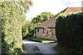
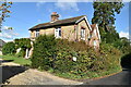
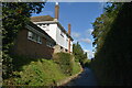
4

House at the Four Wents
The four wents are Plough Wents Road, straight on, Brishing Road to right and left, and Heath Road from behind the camera.
Image: © Robin Webster
Taken: 9 Jul 2012
0.03 miles
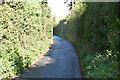
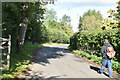
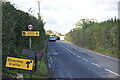
5
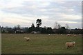
Looking east towards Four Wents
Farmland on the southern edge of Maidstone in Kent.
Image: © David Rayner
Taken: 24 Dec 2005
0.06 miles