IMAGES TAKEN NEAR TO
Orchard Bank, MAIDSTONE, ME17 3SG
Introduction
This page details the photographs taken nearby to Orchard Bank, ME17 3SG by members of the Geograph project.
The Geograph project started in 2005 with the aim of publishing, organising and preserving representative images for every square kilometre of Great Britain, Ireland and the Isle of Man.

There are currently over 7.5m images from over14,400 individuals and you can help contribute to the project by visiting https://www.geograph.org.uk
Image Map
Images are licensed for reuse under creativecommons.org/licenses/by-sa/2.0
Notes
- Clicking on the map will re-center to the selected point.
- The higher the marker number, the further away the image location is from the centre of the postcode.
Image Listing (44 Images Found)
Images are licensed for reuse under creativecommons.org/licenses/by-sa/2.0
Image
Details
Distance
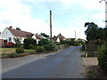
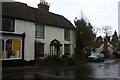
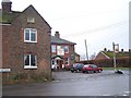
2
The Buffalo's Head, Chart Sutton
On Chart Hill Road.
Also see Image
Image: © Oast House Archive
Taken: 19 Nov 2010
0.06 miles
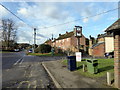
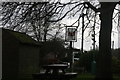
3

Buffalo's Head sign
Subtly covered with an advert for landlords.
Image
Image: © Oast House Archive
Taken: 19 Nov 2010
0.06 miles
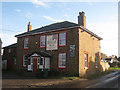
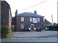
6
The Buffalo's Head, Chart Sutton
Former pub now known as the Lilypie cafe.
Image: © Chris Whippet
Taken: 30 Aug 2013
0.06 miles
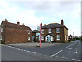
9
Buffalo's Head Pub, Chart Sutton
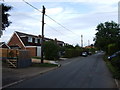
On junction of Warmlake Road (in front) and Chart Hill Road (on right). Seen from Chart Corner Road.
Image: © David Anstiss
Taken: 20 Jan 2009
0.07 miles