IMAGES TAKEN NEAR TO
Bushy Grove, MAIDSTONE, ME17 3QL
Introduction
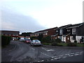
This page details the photographs taken nearby to Bushy Grove, ME17 3QL by members of the Geograph project.
The Geograph project started in 2005 with the aim of publishing, organising and preserving representative images for every square kilometre of Great Britain, Ireland and the Isle of Man.

There are currently over 7.5m images from over14,400 individuals and you can help contribute to the project by visiting https://www.geograph.org.uk
Image Map
Images are licensed for reuse under creativecommons.org/licenses/by-sa/2.0
Notes
- Clicking on the map will re-center to the selected point.
- The higher the marker number, the further away the image location is from the centre of the postcode.
Image Listing (19 Images Found)
Images are licensed for reuse under creativecommons.org/licenses/by-sa/2.0
Image
Details
Distance
10
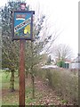
Kingswood Village Sign
On green of Village Hall / Church. On Gravelly Bottom Road. It shows a crown, as Edward I's Queen Eleanor of Castile became owner of Leeds Castle during the 13th Century. It was commissioned by Parish Council, and made by the Coxheath based craftsman Bernard Hill. He has made many Kent village signs.
Image: © David Anstiss
Taken: 24 Feb 2009
0.16 miles