IMAGES TAKEN NEAR TO
Chestnut Drive, MAIDSTONE, ME17 3PP
Introduction
This page details the photographs taken nearby to Chestnut Drive, ME17 3PP by members of the Geograph project.
The Geograph project started in 2005 with the aim of publishing, organising and preserving representative images for every square kilometre of Great Britain, Ireland and the Isle of Man.

There are currently over 7.5m images from over14,400 individuals and you can help contribute to the project by visiting https://www.geograph.org.uk
Image Map
Images are licensed for reuse under creativecommons.org/licenses/by-sa/2.0
Notes
- Clicking on the map will re-center to the selected point.
- The higher the marker number, the further away the image location is from the centre of the postcode.
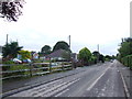
Image Listing (12 Images Found)
Images are licensed for reuse under creativecommons.org/licenses/by-sa/2.0
Image
Details
Distance
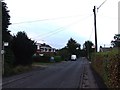
6
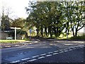
Kingswood road junction
Gravelly Bottom Road crosses Broomfield Road.
Image: © Penny Mayes
Taken: 7 Nov 2005
0.13 miles
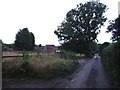
7
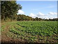
Field beside Gravelly Bottom Road
A change from all the woodland, I think it was a beet crop.
Image: © Penny Mayes
Taken: 7 Nov 2005
0.13 miles