IMAGES TAKEN NEAR TO
Sutton Road, MAIDSTONE, ME17 3NN
Introduction
This page details the photographs taken nearby to Sutton Road, ME17 3NN by members of the Geograph project.
The Geograph project started in 2005 with the aim of publishing, organising and preserving representative images for every square kilometre of Great Britain, Ireland and the Isle of Man.

There are currently over 7.5m images from over14,400 individuals and you can help contribute to the project by visiting https://www.geograph.org.uk
Image Map
Images are licensed for reuse under creativecommons.org/licenses/by-sa/2.0
Notes
- Clicking on the map will re-center to the selected point.
- The higher the marker number, the further away the image location is from the centre of the postcode.
Image Listing (26 Images Found)
Images are licensed for reuse under creativecommons.org/licenses/by-sa/2.0
Image
Details
Distance

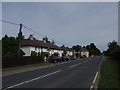
5

Houses opposite bus stop
On Sutton Road (A274)
Image: © Clint Mann
Taken: 16 Feb 2016
0.10 miles

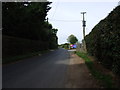
10

A274 at Langley
The lorry is partly parked in the Pear Tree Row bus stop pull-in.
Image: © Robin Webster
Taken: 9 Jul 2012
0.10 miles