IMAGES TAKEN NEAR TO
Sutton Road, MAIDSTONE, ME17 3ND
Introduction
This page details the photographs taken nearby to Sutton Road, ME17 3ND by members of the Geograph project.
The Geograph project started in 2005 with the aim of publishing, organising and preserving representative images for every square kilometre of Great Britain, Ireland and the Isle of Man.

There are currently over 7.5m images from over14,400 individuals and you can help contribute to the project by visiting https://www.geograph.org.uk
Image Map
Images are licensed for reuse under creativecommons.org/licenses/by-sa/2.0
Notes
- Clicking on the map will re-center to the selected point.
- The higher the marker number, the further away the image location is from the centre of the postcode.
Image Listing (20 Images Found)
Images are licensed for reuse under creativecommons.org/licenses/by-sa/2.0
Image
Details
Distance
1
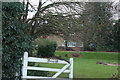
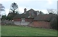
Rumswood Green Farm
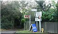
Seen from footpath from Back Street to A274 Sutton Road. This footpath crosses through farm hence warning signs due to various farm vehicles associated to orchards and fruit picking and packaging.
Image: © David Anstiss
Taken: 20 Jan 2009
0.05 miles
2
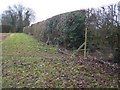
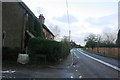
Footpath and Hedge Line
Footpath from Holly Farm Road, goes through Lacey Farm, then comes through hedge into Rumwood Green Farm land, before reaching A274 Sutton Road.
Image: © David Anstiss
Taken: 20 Jan 2009
0.10 miles