IMAGES TAKEN NEAR TO
Warmlake Road, MAIDSTONE, ME17 3LP
Introduction
This page details the photographs taken nearby to Warmlake Road, ME17 3LP by members of the Geograph project.
The Geograph project started in 2005 with the aim of publishing, organising and preserving representative images for every square kilometre of Great Britain, Ireland and the Isle of Man.

There are currently over 7.5m images from over14,400 individuals and you can help contribute to the project by visiting https://www.geograph.org.uk
Image Map
Images are licensed for reuse under creativecommons.org/licenses/by-sa/2.0
Notes
- Clicking on the map will re-center to the selected point.
- The higher the marker number, the further away the image location is from the centre of the postcode.
Image Listing (13 Images Found)
Images are licensed for reuse under creativecommons.org/licenses/by-sa/2.0
Image
Details
Distance
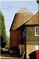
2
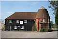
The Oast, Warmlake Business Estate, Sutton Valence, Kent
Image: © Oast House Archive
Taken: 21 Sep 2008
0.06 miles
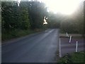
5
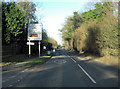
A274 crossroads with Warmlake Road
At this point the 'A' road is also called North Street.
Image: © Stuart Logan
Taken: 16 Jan 2012
0.08 miles
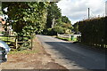
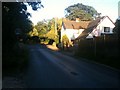
6
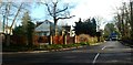
Junction at Chartway Street
At junction of A274 (Maidstone Road) and Chartway Street, north of Sutton Valence.
Image: © Clint Mann
Taken: 16 Feb 2016
0.08 miles