IMAGES TAKEN NEAR TO
Leeds Road, MAIDSTONE, ME17 3JN
Introduction
This page details the photographs taken nearby to Leeds Road, ME17 3JN by members of the Geograph project.
The Geograph project started in 2005 with the aim of publishing, organising and preserving representative images for every square kilometre of Great Britain, Ireland and the Isle of Man.

There are currently over 7.5m images from over14,400 individuals and you can help contribute to the project by visiting https://www.geograph.org.uk
Image Map
Images are licensed for reuse under creativecommons.org/licenses/by-sa/2.0
Notes
- Clicking on the map will re-center to the selected point.
- The higher the marker number, the further away the image location is from the centre of the postcode.
Image Listing (30 Images Found)
Images are licensed for reuse under creativecommons.org/licenses/by-sa/2.0
Image
Details
Distance
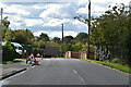
6
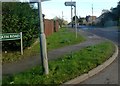
Leeds Road from Heath Road
At Langley Heath. Leeds Road is the B2163.
Image: © Clint Mann
Taken: 16 Feb 2016
0.17 miles
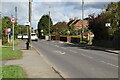
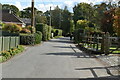
10
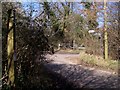
Footpath crosses road junction
Path No.KH29 from Chartway Street, goes through Abbey Wood, then crosses Pitt Road and Gravelly Bottom Road (as they meet and become Ulcombe Road). Path then leads beside Abbey Wood (on right) to B2163 Leeds Road, Langley Heath.
Image: © David Anstiss
Taken: 18 Mar 2009
0.20 miles