IMAGES TAKEN NEAR TO
North Street, MAIDSTONE, ME17 3HR
Introduction
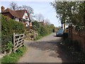
This page details the photographs taken nearby to North Street, ME17 3HR by members of the Geograph project.
The Geograph project started in 2005 with the aim of publishing, organising and preserving representative images for every square kilometre of Great Britain, Ireland and the Isle of Man.

There are currently over 7.5m images from over14,400 individuals and you can help contribute to the project by visiting https://www.geograph.org.uk
Image Map
Images are licensed for reuse under creativecommons.org/licenses/by-sa/2.0
Notes
- Clicking on the map will re-center to the selected point.
- The higher the marker number, the further away the image location is from the centre of the postcode.
Image Listing (182 Images Found)
Images are licensed for reuse under creativecommons.org/licenses/by-sa/2.0
Image
Details
Distance
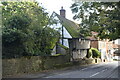
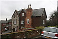
2
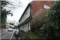
Heaven Cottage
Grade II listed. http://www.britishlistedbuildings.co.uk/en-174174-heaven-cottage-sutton-valence-kent
Image: © N Chadwick
Taken: 25 Nov 2012
0.01 miles
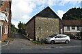
5
Heaven Cottage
Grade II listed. https://historicengland.org.uk/listing/the-list/list-entry/1344323
Image: © N Chadwick
Taken: 11 Oct 2020
0.01 miles
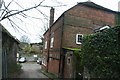
9
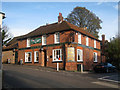
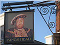
Kings Head, Sutton Valence
At junction of North Street and High Street (to right).
Also see Image
Image: © Oast House Archive
Taken: 19 Nov 2010
0.03 miles