IMAGES TAKEN NEAR TO
Valdene Close, MAIDSTONE, ME17 3GS
Introduction
This page details the photographs taken nearby to Valdene Close, ME17 3GS by members of the Geograph project.
The Geograph project started in 2005 with the aim of publishing, organising and preserving representative images for every square kilometre of Great Britain, Ireland and the Isle of Man.

There are currently over 7.5m images from over14,400 individuals and you can help contribute to the project by visiting https://www.geograph.org.uk
Image Map
Images are licensed for reuse under creativecommons.org/licenses/by-sa/2.0
Notes
- Clicking on the map will re-center to the selected point.
- The higher the marker number, the further away the image location is from the centre of the postcode.
Image Listing (29 Images Found)
Images are licensed for reuse under creativecommons.org/licenses/by-sa/2.0
Image
Details
Distance
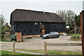
1
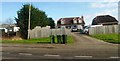
Valedene Industrial Park, neat Sutton Valence
Image: © Chris Whippet
Taken: 15 Sep 2013
0.02 miles
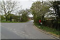
2
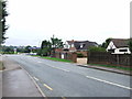
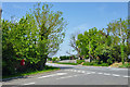
A274 between Headcorn and Sutton Valence
Image: © Clint Mann
Taken: 16 Feb 2016
0.02 miles
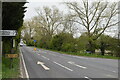
5
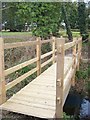
Footbridge near Gladwish Bungalow
This footbridge allows walkers to cross stream beside A274 Headcorn Road, near the newly finished house. The path No.KH503 leads to Heniker Lane.
Image: © David Anstiss
Taken: 26 Feb 2009
0.07 miles
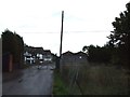
6
Post box at the junction
New Barn Road meets the A274, Headcoern Road.
Image: © Robin Webster
Taken: 22 May 2012
0.08 miles
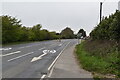
7
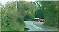
Junction of New Barn Road with Headcorn Road
Headcorn Road is the A274
Image: © Clint Mann
Taken: 29 Oct 2015
0.08 miles