IMAGES TAKEN NEAR TO
Stickfast Lane, MAIDSTONE, ME17 3DZ
Introduction
This page details the photographs taken nearby to Stickfast Lane, ME17 3DZ by members of the Geograph project.
The Geograph project started in 2005 with the aim of publishing, organising and preserving representative images for every square kilometre of Great Britain, Ireland and the Isle of Man.

There are currently over 7.5m images from over14,400 individuals and you can help contribute to the project by visiting https://www.geograph.org.uk
Image Map
Images are licensed for reuse under creativecommons.org/licenses/by-sa/2.0
Notes
- Clicking on the map will re-center to the selected point.
- The higher the marker number, the further away the image location is from the centre of the postcode.
Image Listing (9 Images Found)
Images are licensed for reuse under creativecommons.org/licenses/by-sa/2.0
Image
Details
Distance
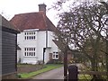
4
Brissenden House
On East Sutton Road.
Image: © David Anstiss
Taken: 19 Mar 2009
0.08 miles

6

The Start of Tong Lane
Looking across Stickfast Lane along the by-way
Image: © Glyn Baker
Taken: 17 Feb 2019
0.08 miles
7

Stile But No Path
This stile has no indication of a permissive footpath or public access.
Image: © Glyn Baker
Taken: 17 Feb 2019
0.08 miles